GeoApps Logo
Apps
Solutions
Platform
About us
Get adviceLogin
MapServices hero background
MapServices icon

MapServices

Professional hosting and management of your map services. We ensure reliable and secure access to your geodata.

Contact usView data packages
MapServices professional hosting and data services hero

Trusted by Leading Organizations

Join 300+ organizations worldwide who trust MapServices for their geographic data needs

  • Gemeente Rotterdam
  • Arcadis
  • Stantec
  • Enexis
  • ProRail
  • Tauw
  • Natuurmonumenten
  • Provincie Overijssel
  • Regio Foodvalley
  • Mapification
  • Arup
  • Kragten
  • Waternet
  • FactoGeo
  • Keypoint
  • Gemeente Enschede
  • Qwello
  • Procap
  • Rabobank
  • Aventus
  • Ecogroen
  • Woonbedrijf
  • Q-Estate
  • Transitiemakers
  • Deloitte
  • Gemeente Haarlemmermeer
  • Regio Stedendriehoek
  • Collectie Overijssel
  • Duurzaamheidskaart
  • Omgevingswarmtekaart
  • Assetmaps
  • Gemeente Utrecht
  • Gemeente Hengelo
  • Gemeente Apeldoorn
  • Gemeente Maastricht
  • Gemeente Ede
  • Gemeente Epe
  • Gemeente Gennep
  • Gemeente Maasgouw
  • Gemeente Wierden
  • Gemeente Zundert
  • Gemeente Deventer
  • Gemeente Dordrecht
  • Gemeente Rijswijk
  • Gemeente Leiden
  • Gemeente Sittard-Geleen
  • Westerkwartier
  • Gemeente Groningen
  • Gemeente Voorst
  • Provincie Utrecht
  • Provincie Gelderland
  • Provincie Noord-Holland
  • Provincie Flevoland
  • Provincie Groningen
  • Provincie Drenthe
  • Dekker Groep
  • Van Dun Advies
  • Roelofs
  • Roelofs Lemelerveld
  • Nouryon
  • Syntraal
  • Stedin
  • CCS Energie-advies
  • PraatMee
  • MapServices
  • Satellic
  • Wegenscanners
  • Zone College
  • Stadscampus De Kien
  • Saxion
  • Natuur en Milieufederaties
  • Omgevingsdienst Brabant-Noord
  • RVO
  • Omroep Brabant
  • Thius
  • Tijdlab
  • Mateboer
  • Aveco de Bondt
  • Riese & Geurts
  • OMWB
  • TTE
  • KWR
  • Lycens
  • Nordend
  • Royal HaskoningDHV
  • MapGear

Webservices

Professional hosting and management of your map services. We ensure reliable and secure access to your geodata via modern web services.

Hosting & Management

Reliable hosting of your map services with 24/7 monitoring and management.

Reliable hosting of your map services with 24/7 monitoring and management.

Request Demo

Service Catalogue

Comprehensive catalog of map services and solutions

Browse our complete catalog of map services, from basic hosting to advanced data management solutions.

View Catalogue

All Required Functionality

Professional Hosting

Reliable cloud-based hosting with 99.9% uptime guarantee and 24/7 monitoring

Service Management

Comprehensive management tools for monitoring, scaling, and maintaining your map services

Data Services

Real-time data access through standard protocols (WMS, WFS, WMTS) with caching and optimization

Security Services

Enterprise-grade security with SSL encryption, authentication, and access control

View our service catalogue

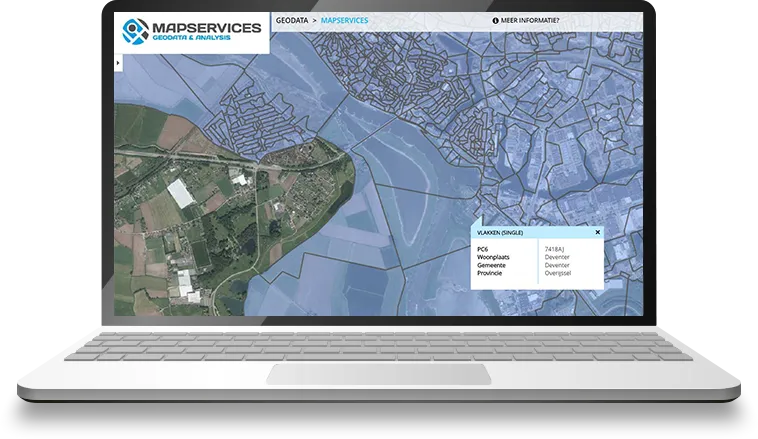
Explore our MapServices and geodata in the viewer below. You can toggle layers and browse the catalogue.

Loading catalogue…
Open catalogue in new tab

Discover our geodata packages

Use our geodata in MapServices or request a data package. From postcodes to building information and sustainability: we deliver the data you need for analysis and planning.

Postcode Information

National postcode areas for the entire Netherlands with detailed travel distances and times, suitable for geographic analysis and logistics planning with monthly data updates.

Available datasets:

National postcode areas
Travel distances and times
Postcode table
Request this data package

Sustainability

Extensive datasets for sustainability and energy, including solar potential analyses for buildings and energy labels, with insight into energy consumption for effective energy transition.

Available datasets:

Solar map
Solar monitor
Energy labels
Request this data package

Height Information

Current height data of the Netherlands (AHN) with detailed height values per point and area, ideal for water analyses with regular AHN updates.

Available datasets:

Height points (AHN)
Height database
Height per postcode
Request this data package

Address and Building Information

Complete BAG dataset with addresses, building functions and characteristics, including geocoding and spatial analyses with daily updates of all building data.

Available datasets:

Address database
Building contours (BAG)
Building functions
Roof surfaces
Housing types
Address coordinates
Request this data package

CBS Data

Extensive statistical data from CBS with demographic key figures and socio-economic information at municipal and provincial level, provided with quarterly updates.

Available datasets:

Population statistics
Income and employment
Housing stock
Energy consumption
Provincial map
Municipal map
Request this data package

Ready to get started with MapServices?

Contact us today for a demo or to learn more about our services.

Contact us View demo
GeoApps Viewer
Gasfabriek project
MapGear team office

Frequently asked questions about MapServices

Answers to common questions about hosting, management, and use of MapServices.

What exactly is MapServices?
MapServices is our specialized service for professional hosting and management of map services (WMS, WFS, WMTS). We provide reliable, secure access to your geodata via modern web services with 24/7 monitoring and management.
What geodata is available?
We offer an extensive collection of geodata: postcode information, sustainability data (solar map, energy labels), height data (AHN), BAG building information, and CBS statistics. Additionally, you can host and manage your own datasets.
How does hosting and management work?
We host your MapServices in the cloud with 99.9% uptime guarantee. Our team handles monitoring, backups, updates, and scaling. You maintain full control via a management portal, while we maintain the technical infrastructure.
Which protocols are supported?
We support standard OGC protocols such as WMS (Web Map Service), WFS (Web Feature Service), and WMTS (Web Map Tile Service). We also offer RESTful APIs and webhooks for advanced integrations.
How does pricing work?
Pricing is based on the number of services, data storage, and usage. We offer flexible subscription models that scale with your needs. Contact us for a custom quote.
Can we host our own data?
Yes, absolutely. We host and manage your own geodata and map services. We help convert and optimize your data and ensure reliable access via standard web services.
GeoApps Logo

GeoApps is the leading software platform for GIS applications and spatial data, enabling organizations to make data-driven decisions.

Solutions

  • Urban Planning
  • Infrastructure
  • Real Estate
  • Environment & Climate
  • Energy Transition
  • Safety & Risk

Products

  • GeoApps
  • Solutions
  • Sustainability Map
  • MapServices
  • TouchTable
  • Consultation

Apps

  • Viewer
  • Dashboard
  • Fieldwork
  • MapTour
  • MapTalk
  • Custom

For whom?

  • Municipalities
  • Provinces
  • Environmental Services
  • Engineering
  • Contractors
  • Safety Regions

Platform

  • Integrations
  • Documentation
  • System Status
  • Changelog
  • Support
  • Subscriptions

Company

  • About Us
  • Careers
  • Contact
  • Partners
  • News & Blog
  • Events

Stay up-to-date

Subscribe to our newsletter to get the latest updates on our products and services. You can unsubscribe at any time.

Keep an eye on our socials too

Stay connected with us through our social media channels and get the latest updates on our products and services.

Quality & trust

MapGear is ISO 9001 and ISO 27001 certified and meets the highest quality and security standards for our products and services.

ISO 9001 Certificering
ISO 27001 Certificering
QGIS Membership 2026

© 2026 GeoApps, a product of MapGear B.V.

Privacy PolicyTerms of Service