Interactive storytelling with location as a common thread
Bring locations to life with GeoApps MapTour – an accessible way to present projects and plans as an interactive map tour. Ideal as a digital project website, narrative route, or visual explanation for thematic maps or area developments.
Request a demo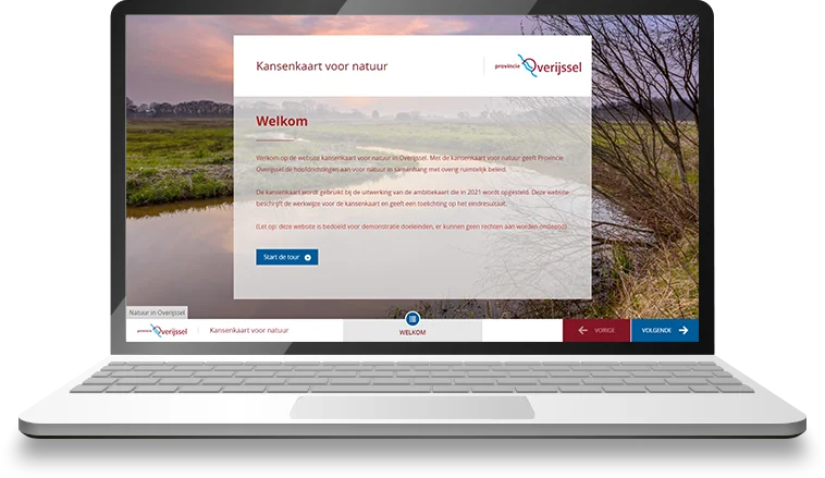
Trusted by storytellers worldwide
From museums and educational institutions to tourism organizations – MapTour is the preferred choice for interactive spatial storytelling.


Why choose MapTour?
Turn your maps into convincing, interactive stories – with powerful tools for visual communication and location-based storytelling.
Engage audiences
Tell your story in a way that informs and inspires – ideal for colleagues, project partners, or stakeholders.
Easy to assemble
Assemble your map tour in a few simple steps with the intuitive Editor. Effortlessly combine text, images, video, and maps.
Publish and share directly
Publish your MapTour online and easily share it via web or mobile devices.
Collaborate on one story
Build tours together with colleagues, with clear roles and rights per user.
Visual map presentations
Your urban planning mapped – with media, navigation, and location-specific explanations. Discover the powerful tools that make MapTour the perfect solution for interactive storytelling.


Multimedia
Easily add photos, videos, and audio – including support for YouTube and Vimeo, among others.
A clear story per location or topic
Put every place or theme on the map, including explanation or context – ideal for topics, routes, or area developments.
Responsive design
The MapTour works smoothly on any device – from desktop to tablet, smartphone, and TouchTable.
Smooth navigation
Guide users step by step through your story with a logical sequence and simple operation.
Easy sharing
Publish with one click and share via link or QR code.
Applicable to any story
From heritage routes to area development – MapTour easily adapts to your goal and target audience.
Tourism and marketing
Highlight destinations or routes with appealing, visual presentations.
Urban planning
Present spatial plans and designs with maps, images, and clear explanations per location.
Cultural heritage
Bring historical places and stories to life with interactive tours full of images and context.
Experiences of our customers
Discover how organizations use GeoApps MapTour to present plans, routes, and stories via interactive map tours. Ideal for communication, participation, and public information.

Syntraal
"With MapTour, we can tell stories in a way that really touches people. The combination of maps and multimedia makes complex information accessible."
Simon Bos, Business Developer
Ready to bring your story to life?
Create an interactive MapTour yourself and discover how easy it is to present plans, routes, or projects in an engaging way.


MapTour FAQ
Frequently asked questions about creating and using interactive map tours with GeoApps MapTour.