GeoApps Logo
Apps
Solutions
Platform
About us
Get adviceLogin
  1. Home
  2. Apps
  3. Dashboard
Dashboard icon
Dashboard

From data to insight

Easily create interactive dashboards that make complex spatial data understandable and help in making the right decisions.

Request a demo
Dashboard Interface

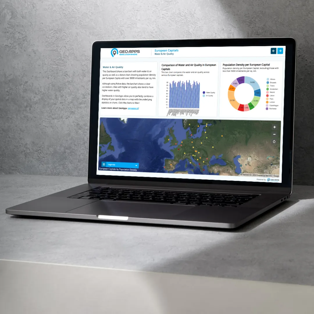
Trusted by data-driven organizations

Governments, consultancy firms, and other organizations use GeoApps Dashboard to translate their data into insights that lead to smart, targeted action.

  • Enexis
  • Gemeente Rotterdam
  • Provincie Overijssel
  • Duurzaamheidskaart
  • Syntraal
  • CCS Energie-advies
  • Stantec
  • Enexis
  • Gemeente Rotterdam
  • Provincie Overijssel
  • Duurzaamheidskaart
  • Syntraal
  • CCS Energie-advies
  • Stantec
  • Transitiemakers
  • Gemeente Rijswijk
  • Provincie Noord-Holland
  • Omgevingswarmtekaart
  • Procap
  • Riese & Geurts
  • Transitiemakers
  • Gemeente Rijswijk
  • Provincie Noord-Holland
  • Omgevingswarmtekaart
  • Procap
  • Riese & Geurts

Why Choose GeoApps Dashboard?

Discover how GeoApps Dashboard transforms complex data into clear, actionable insights that drive better decision-making.

Better Decisions

Turn complex data into clear, actionable insights that align your organization.

Real-time Insights

Stay ahead with live dashboards fed by always up-to-date data.

Seamless Collaboration

Share securely with the right people and work efficiently across teams.

How GeoApps users leverage Dashboards

See how organizations use GeoApps Dashboards to visualize data and drive action

Workflow Dashboard
Workflow

Operational performance monitoring

Keep track of processes and KPIs with clear visualizations and up-to-date status.

Operational performance monitoring

Keep track of processes and KPIs with clear visualizations and up-to-date status.

99.8%
Accuracy

How to build your dashboard

Create professional dashboards in three simple steps.

Choose your data
1

Choose your data

Use data from various sources such as GIS services, spreadsheets, or data already in GeoApps.

Design your layout
2

Design your layout

Combine maps, charts and indicators – fully in your brand style and tailored to your needs.

Publish and share
3

Publish and share

Publish your dashboard and securely share it with colleagues and partners – always up to date and available everywhere.

What users say

See how organizations are transforming data visualization with GeoApps Dashboard
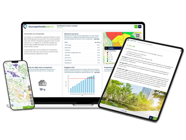
Duurzaamheidskaart

Duurzaamheidskaart

"GeoApps has helped us make sustainability data accessible to everyone. The platform combines powerful visualization with simple user experience."

Dominique Goes, Duurzaamheidskaart.nl

Project Manager

What GeoApps Dashboard enables

A complete set of features for professional dashboards – scalable, secure and collaboration-ready.

Automation

Schedule updates, calculations and refresh – less manual work, always up to date.

Security

Role-based access, encryption, and SSO/AD integration for enterprise-grade security.

Customizable

Fully in your corporate style with your own color schemes, icons and layout.

API & integrations

Connect external systems and feed dashboards with data via modern APIs.

Export

Export tables, maps and visualizations – including reports in your brand style.

Alerts

Configure thresholds and receive notifications on important changes.

Data source integrations

Combine GIS services, databases and files into a single consistent dashboard.

Performance

Fast rendering – even with large datasets – with smart caching and real-time refresh.

Reporting

Generate insights and share periodic reports for policy and decision‑making.

Ready to turn your data into insight?

Experience for yourself how GeoApps Dashboard works for your organization. Request a demo and discover how easy it is to create valuable insights.

Contact Us
GeoApps Viewer
Gasfabriek project
MapGear team office

Dashboard FAQ

Frequently asked questions about creating and using interactive dashboards with GeoApps Dashboard.

What is GeoApps Dashboard?
GeoApps Dashboard is a powerful tool for creating interactive data visualizations that combine maps, charts, and indicators. It transforms complex spatial data into clear, actionable insights for better decision-making.
What data sources can I connect?
You can connect various data sources including GIS services, spreadsheets, databases, web services, and existing GeoApps data. The platform supports multiple formats and protocols for seamless integration.
Is Dashboard real-time?
Yes, dashboards can be configured to update automatically based on current data. You can set refresh intervals and schedule updates to ensure your visualizations always show the latest information.
Can I customize the design?
Absolutely. Dashboards can be fully customized with your brand colors, logos, typography, and layout. Create professional-looking visualizations that match your organization's style.
How do I share dashboards?
Published dashboards can be shared securely with colleagues and partners. Role-based access control ensures the right people see the right information, and you can embed dashboards on websites or share direct links.
Is Dashboard secure?
Yes, enterprise-grade security features include role-based access control, data encryption, SSO/Active Directory integration, and comprehensive audit logging. Your data remains secure and compliant.
GeoApps Logo

GeoApps is the leading software platform for GIS applications and spatial data, enabling organizations to make data-driven decisions.

Solutions

  • Urban Planning
  • Infrastructure
  • Real Estate
  • Environment & Climate
  • Energy Transition
  • Safety & Risk

Products

  • GeoApps
  • Solutions
  • Sustainability Map
  • MapServices
  • TouchTable
  • Consultation

Apps

  • Viewer
  • Dashboard
  • Fieldwork
  • MapTour
  • MapTalk
  • Custom

For whom?

  • Municipalities
  • Provinces
  • Environmental Services
  • Engineering
  • Contractors
  • Safety Regions

Platform

  • Integrations
  • Documentation
  • System Status
  • Changelog
  • Support
  • Subscriptions

Company

  • About Us
  • Careers
  • Contact
  • Partners
  • News & Blog
  • Events

Stay up-to-date

Subscribe to our newsletter to get the latest updates on our products and services. You can unsubscribe at any time.

Keep an eye on our socials too

Stay connected with us through our social media channels and get the latest updates on our products and services.

Quality & trust

MapGear is ISO 9001 and ISO 27001 certified and meets the highest quality and security standards for our products and services.

ISO 9001 Certificering
ISO 27001 Certificering
QGIS Membership 2026

© 2026 GeoApps, a product of MapGear B.V.

Privacy PolicyTerms of Service